
Public Lands
 Public lands are lands owned in common by all. Public lands are held in trust by governments, which also exercise authority for control or use of these lands. In Canada public lands are called Crown lands - a reference to our British Commonwealth history. Public lands are distinct from private lands; individual citizens can not own public land. Canada's public lands belong to all Canadians.
In Canada, 41% of our total land base is federal crown land and 48% is provincial crown land (includes water) - a total of 89%. Less than 11% of Canada's land is in private hands. Source: The Canadian Encyclopedia
The total land and fresh water area of Manitoba is 64,779,700 hectares with the land only area being 55,355,600 hectares. Approximately 90% of land in Manitoba is Crown or public land with the remaining 10% being private. Source: PDAC
Crown lands in Manitoba are administered through the Crown Lands Act, which defines Crown land in Manitoba as follows: "Crown lands" includes land, whether within or without the province, vested in the Crown, and includes "provincial lands" wherever that expression is used in an Act of the Legislature.
The Crown Lands Act gives the provincial government (through Cabinet) and the Minister responsible for administration of the Act) discretionary power to issue permits, licences and leases that grant a temporary or permanent right or interest to use, access or occupy Crown lands (Crown Lands Act, Section 5(1)). Government can also purchase, exchange or dispose of (sell) Crown lands or 'designate' particular areas such that certain activities and/or uses are permitted or prohibited within the defined (designated) area (Crown Lands Act, Section 5(1)). For instance, lands can be designated as
Similarly, Crown lands can be set aside for public usage, such as wharves or piers, market places, jails, court houses, highways, historic sites, town sites, hospitals, or schools. View Manitoba's Crown Lands ActMany other Manitoba Acts affect decisions regarding Crown lands or/and waters. For a listing of some of these, visit Manitoba Wildlands' Manitoba Government page. Public policy also affects the use and management of Manitoba's Crown / public lands. For a listing and links of Manitoba government policies regarding lands and waters, from fall 1999 through to 2006, visit Manitoba Wildands' Manitoba Government page. |
|||||||||||||
| There are different regulations governing activities that can and can not take place on crown lands, as compared to private lands. Permits are required for certain development activities (as defined under Manitoba's Environment Act). This includes mining (exploration, extraction), energy generation and transmission, forestry, and road building, among others. Other activities on crown land that are not projects as defined by the Environment Act may also require permits under other Acts, such as fishing, hunting, building construction, lodges, outfitters, etc. Resource extraction is regulated by, for instance, Mines Act, Forestry Act, etc. |
Manitoba Government Land Use Planning Area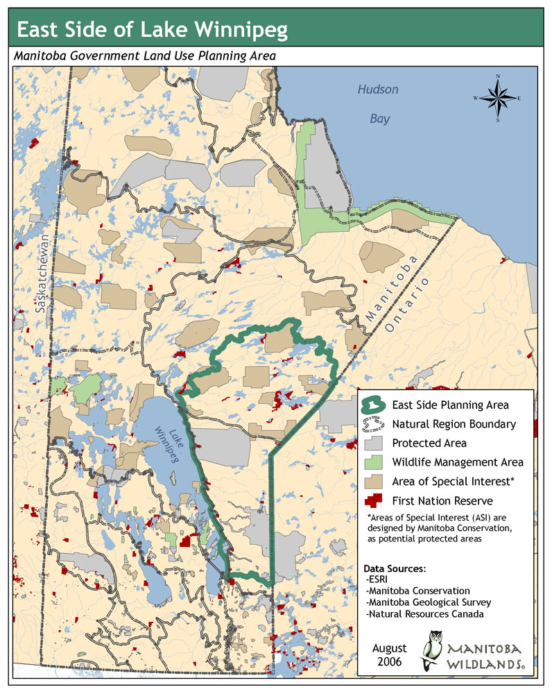 Larger Version |
||||||||||||
| Certain groups of people are exempt from requirements for permits for specific activities. For instance, Manitoba Status Indians (First Nations citizens) do not require permits to exercise their traditional Aboriginal and Treaty rights (for example to hunt and fish) on Crown land. See Aboriginal Rights & Title, Treaties and Traditional Territory. Crown land designations in Manitoba include:
For more information about protected area designations in Manitoba, view Manitoba Wildlands' information on the Protected Areas Initiative. |
|||||||||||||
Public Lands in Municipalities
Although a great deal of Manitoba's land is public land, Manitoba municipalities in the southern third of the province are comprised of a combination of private and public lands. This is a result of how the province was settled; many people came to Manitoba to farm the land and a great deal of the land, especially along the main rivers in southern Manitoba, was granted to early settlers. Conservation Districts |
|
| Conservation Districts are a unique feature of southern Manitoba. A Conservation District (CD) is a group of neighboring rural municipalities (RMs) working in partnership with the Province of Manitoba to develop programs to effectively manage the natural, and water resources of their area. Conservation Districts include Crown and private lands. Land-owners work with each other, the municipality and the province to develop and implement programs within each Conservation District. Currently, there are 16 CDs in Manitoba covering over 60% of the areas known as Agro-Manitoba. | Manitoba's Conservation Districts Map 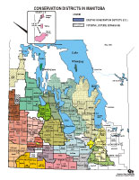 Larger Version (PDF) |
Conservation District boundaries may vary, however they are usually based on the drainage basin or watershed of the major river in the area. Visit the Manitoba Water Stewardship Department's Conservation Districts page Visit the Manitoba Conservation Districts Association website |
|
Federal Public Lands in Manitoba
| Public lands under federal jurisdiction include Department of National Defense (DND) lands, although some of the lands used by DND in Manitoba are provincial Crown lands - for example, much of the Canadian Forces Base (CFB)/Area Support Unit Shilo. First Nation/Indian Reserve lands are also under federal jurisdiction. Reserve lands are federal lands that have been set aside for the exclusive use and benefit of the Indian Band(s) to which it is assigned. |
Reports - Public Lands
 In 2003, Manitoba released a report entitled Crown Lands Review: Final Report. The report examines Crown land policies and processes for the administration, sale and lease of Crown lands. The report makes several recommendations concerning: In 2003, Manitoba released a report entitled Crown Lands Review: Final Report. The report examines Crown land policies and processes for the administration, sale and lease of Crown lands. The report makes several recommendations concerning:
 Download 2003 Crown Lands Review: Final Report (PDF) Download 2003 Crown Lands Review: Final Report (PDF)A review of Crown land transactions by Manitoba's Auditor General is ongoing. The 2003 Crown Lands Review: Final Report is part of this review. The Auditor General released a report in 2003 investigating transactions associated with Hecla Island. Download Investigation of Hecla Island Land and Property Transactions (PDF)Ontario Land Use PlanningDownload Northern Boreal Initiative October 2002, Community-based Land Use Planning Report (PDF)Lands and Waters Brief ReportsManitoba Wildlands is posting a series of briefs to provide an overview to various ongoing protected areas and land use planning issues. Watch for new briefs.Download Brief: First Nation Protected Areas MOU (PDF)Download Brief: Protected Areas: Manitoba Legislation & Policy (PDF)Download Brief: East Side Planning Initiative/Wabanong Nakaygum Okmawin (PDF) Updated May 2007Download Brief: Protected Areas and First Nation Resource Stewardship Accord/WHS Nomination (PDF)Download Brief: Heritage Rivers (PDF)Download Brief: The Oral Tradition, Oral History Research & Traditional Use Studies (PDF)Download Brief: Land Use Plans (PDF) |
Métis Lands
For more information, Click here
Aboriginal Rights & Title,
Treaties & Traditional Territory
For more information, Click here
Duty to Consult with
Aboriginal Peoples
For more information, Click here
Aboriginal Court Cases
& Consultations
For more information, Click here
 2002-2014