
Economic Development
Transportation
Manitoba Highway Speed Increase ReportManitoba's proposed 2008 increase to speed limits on the four lane Highways; 1 and 75, is raising environmental, economic, and safety concerns. The Manitoba Government contracted a report, which claims a 2.5 percent increase in speed could result in a 12 percent increase in fatalities and 7 percent increase in serious personal injuries. Highway Traffic Board hearings will be held during February 2008. For hearing details go to our Calendar. Download October 2007 Manitoba Infrastructure and Transportation Executive Summary (PDF) Download October 2007 Manitoba Infrastructure and Transportation Executive Summary (PDF)View January 17, 2008 Manitoba Wildlands news item  2020 - Manitoba's Transportation Vision InitiativeIn July 2005, the Minister of Transportation & Government Services released the report and recommendations of the 2020 Transport Vision Steering Committee.Eleven general themes and recommendations for each theme are presented in the 2020 Transport Vision report. According to the Steering Committee, these themes are necessary to a comprehensive transportation plan.
 Download the July 2005 report, 2020-Manitoba Transportation Vision - Strategic Directions Report (PDF)
View the July 14, 2005 Transportation and Government Services press release The report is the result of a process that began on April 25, 2002 with the announcement of the 2020 - Manitoba's Transportation Vision initiative by the Minister of Transportation & Government Services. The 2020 Transport Vision initiative was a process to develop a long-term transportation investment plan. The mandated task given to the ten-member 2020 Transport Vision Steering Committee was to consult with the broader public on the state of Manitoba's transportation infrastructure. Over two years, the Steering Committee conducted public workshops in 15 Manitoba communities, and hosted 7 other open public meetings. The steering committee also used a public opinion survey, comment forms, written submissions, e-mail, and a telephone hot line to gain input from members of the public. According to the 2020 Transport Vision web site, the government will also be seeking more suggestions and feedback as it moves forward with a long-term transportation investment plan. However, no details as to the next steps for this process or when they will occur have been provided. Nunavut & Manitoba Planning Road LinkThe Manitoba-Nunavut road is initially intended to be a winter road, with an eventual up-grade to an all-weather, all-season road. From Rankin Inlet, the route will proceed south to connect with Manitoba's all-weather road system at Lynn Lake, Thompson or Gillam. The Port of Churchill will also be connected to the route. A technical process was initiated to identify feasible all-weather road route alternatives. These selected routes were based on the collection and analysis of topographic and geological routing control information as well as on the collection and evaluation of social, economic and environmental information. This information was coordinated and analyzed to identify opportunities and issues associated with the selection of three competing alternative road routes. Alternative routes generated by the consultant team were presented to the Project Advisory Council and the general public during the first round of community meetings, which were completed in October 2006. 15 meetings were held in communities in Kivalliq and northern Manitoba. Meetings were held with First Nations organizations and selected non-government organizations (including the Keewatinook Ininew Okimowin (MKIO), the Beverly and Qamanirjuaq Caribou Management Board, Thompson Unlimited and the Hudson Bay Neighbours Regional Round Table). The routes were also shown to Manitoba Conservation, who suggested modifications to avoid provincial parks and areas of special interest. Following the completion of the first round of public meetings, the consultant team reduced the number of alternatives to three - a western route, a central route, and an eastern route - based on community input and best engineering judgment. All three potential routes include a northern common route. |
|
Study Key Map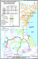 |
The consultant team used an approach called 'Multiple Account Evaluation (MAE)' to compare the three potential routes, resulting in selection of the eastern route as the favoured route. The second round of public meetings was held during February 2007, with meetings taking place in Rankin Inlet, Whale Cove, Arviat, Churchill and Thompson. Project Advisory Council meetings also took place in February 2007 in Rankin Inlet and Thompson. Stakeholders and communities were asked to provide input to the study team in order to confirm and refine the location of the preferred route. |
| Download 2003 Nunavut Transportation System - Evolving for Nunavummiut and Their Economy (PDF) View February 2006 Building the Case for the Proposed Route through Lynn Lake and Northwestern Manitoba for the Manitoba/Nunavut Road Route Selection Study Download May 2007 Tibbitt To Contwoyto Winter Road -Transport Challenges: A Perspective from the Diamond Mines (PDF)Visit website of consulting firm of Nishi-Khon/SNC-Lavalin Visit SNC-Lavalin Nunavut-Manitoba Selection Study website Although the Nunavut-Manitoba Selection Study website indicates the study was completed December 2007, the study itself has not been posted as of August 2009. Public consultation materials - maps of route alternatives, presentation materials and newsletters from the two rounds of public consultations - are available. View 2005-06 public consultation materialView 2007 public consultation material View Final newsletters No public meetings were held in Winnipeg or outside of affected communities and the general public was not notified of meetings or offered the opportunity to provide feedback on the proposed route alternatives. Source: Nishi-Khon/SNC-Lavalin |
|
East Side All-Weather Road Route Selection |
|
| The Manitoba Government announced an intention to undertake a route selection process for an east side all-weather road system in April 2007. A request for proposals will be issued in late 2007 to undertake the selection process. Infrastructure and Transportation Minister Ron Lemieux indicated in an April 20, 2007 press release that Manitoba has "written to the federal government to ensure it will be a full partner in the process." The geographic scope under consideration is an area that extends from the vicinity of Manigotagan in the south to Oxford House in the north, and from Lake Winnipeg on the west to the Ontario border. |
Rice River Road Extension Options Map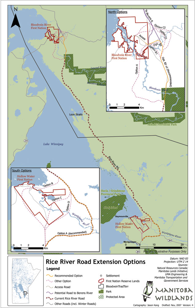 Larger Version |
| First Nation communities in the region include: Bloodvein River, Berens River, Poplar River, Little Grand Rapids, Pauingassi, St. Theresa Point, Waasagomach, Garden Hill, Red Sucker Lake, Norway House, Cross Lake, Oxford House, Gods River and Gods Lake Narrows. Discussions about a transportation network study for the east side have been ongoing for several years. To date there has been no commitment by Canada's federal government to share costs for such a network. In the face of climate change community access needs have increased. View the April 20, 2007 Government of Manitoba press release Source: Government of Manitoba
Manitoba Commits Funds for Bloodvein River Road Infrastructure and Transportation Minister Ron Lemieux announced a commitment of $15 million for construction and upgrades to the Rice River Road on Manitoba's east side April 5, 2007. The announcement reflects references in the April 4, 2007 Manitoba Budget Speech.
 The funds are to be spent over the next five years to rebuild the existing Rice River Road and extend it to Bloodvein River First Nation. This will involve upgrading the entire 90 km route, creating necessary bridge links. The provincial funds announced are a fraction of the total costs. Federal funds will be needed to undertake the road project. The engineering study for the extension and upgrade of the Rice River Road to Bloodvein was initiated in 2002 but wasn't released until fall 2005 (see below). This study is not available to the public, and is not available in electronic format. The Rice River Road was originally constructed for use in logging operations by Pine Falls Paper Company, now owned by Tembec. It is considered to be the main stem for an all-weather road system for the east side of Lake Winnipeg. View the April 5, 2007 Government of Manitoba press release The April 2007 announcement provided no information regarding the environmental review and licensing process that precedes construction. The Manitoba Government indicated it is continuing to seek federal assistance to share costs of construction work and has begun negotiations to undertake a cost-shared, wide-area transportation network. A 2000 preliminary scoping study estimated the cost of an all-weather transportation network for Manitoba's east side at close to $1 million per kilometer of all-weather road. The full road system for the east side would require several hundred kilometers. Detailed socio-economic, environmental analyses of costs and benefits of potential routes for this all-weather road system have not yet been undertaken. View the November 8, 2000 Government of Manitoba press release View the Executive Summary for the 2000 East Side of Lake Winnipeg Road Scoping and Justification Study by H.N Westdal & Associates and Dillon Consulting Download the Review of the 2000 East Side of Lake Winnipeg Road Scoping and Justification Study (PDF)Source: Government of Manitoba
East Side Road GHG Report - CommentsEnvironment Canada conducted a scoping exercise with respect to federal responsibilities for the current ESRA project during 2010 and is currently completing its comprehensive study of the project ( road from Hollow Water to Berens River). Manitoba Wildlands is participating in the comprehensive study. We also responded to the Environment Impact Statement from the ESRA in 2010, and made recommendations for the Environment Canada scoping for the project. Our review of the ESRA Green House Gases Report, as required under its provincial environment licence, is posted below.
All Season Provincial Road 304 to Berens River
Download attachments:
Regulatory steps for the all season highway have begun. Manitoba Wildlands follows the public process and commitments for the all weather road (currently Winter road only) along the East Side of Lake Winnipeg. The resources below provide an update as to next steps, largely based on provincial funds.
Manitoba Wildlands reviewed the East Side Road Authority EIA for the project that includes Rice River Road to Berens River, to become all season road.
East Side Rice River Road StudyThe Rice River road was originally constructed by the Pine Falls Paper Company (now Tembec) as a logging road in the 1970s and l980s. It is also the first part of the winter road to communities north along the east side of Lake Winnipeg and the Island Lake area. The report evaluates several options and identifies a recommended alignment for extending the Rice River Road to Bloodvein First Nation. The full report and executive summary are not available online and are not listed in any public registry file. Contact the Highway Planning and Design Branch of Manitoba Transportation and Government Services (204.945.5225) or UMA Engineering (204.284.0580) View the Existing and Proposed Roads - East Side Manitoba Map In 2009 the Manitoba government established a separate agency regarding the East Side highway, called the East Side Road Authority Inc. View the January 31, 2009 Vice-President job posting for East Side Road AuthorityIn 2009 the contract was awarded to SNC Lavillin. To request a CD copy of the engineering study, contact our Webmaster |
|
 2002-2014