
Economic Development
| This page provides information about development decisions that affect Manitoba's public lands and water. Certain provincial government departments and agencies involved in development intentions are listed. Manitoba's environmental licensing mechanisms and processes are provided, with links. Watch News for stories about development intentions. See also Consultations/Legislation for a listing of what's going on in Manitoba. |
Budget Act Kills Environmental Protection The Government of Canada introduced "Bill C-38: An Act to implement certain provisions of the budget tabled in Parliament on March 29, 2012 and other measures" April 26, 2012.
Bill C-38 is the first of two budget implementation acts. Debate on Bill C-38 begins on May 3, 2012 and passage is expected before the end May. The second budget bill comes to the Commons in the fall and becomes law by the end of the year. At 420 pages Bill C-38 is among the longest budget implementation bills ever. About one-third of the budget implementation bill changes environmental legislation, instead of dealing with fiscal matters as a budget implementation bill does in the Canadian System. Non-budgetary environmental changes in Bill C-38 include:
This is the third time the current Government of Canada has used budget implementation bills to change environmental laws. In 2009 and 2010 the current Government used the budget implementation act to amend environmental laws such as the Navigable Waters Act and Canadian Environmental Assessment Act. Critics aren't happy such fundamental changes to environment law are contained in a budget bill and won't get the scrutiny they deserve. Changes to environmental laws made as stand-alone legislation, are subject to comprehensive analysis, review by the Environment Committee and/or environmental experts, and hearings or debate by members of Parliament. "The legal protection for fish habitat has been completely eliminated," said Jessica Clogg, executive director and senior lawyer for West Coast Environmental Law. "It is an affront to democracy to bury such far-reaching changes to laws Canadians depend upon to help protect our environment in the budget implementation bill in order to avoid public scrutiny," said Greenpeace spokesman Keith Stewart. "The Conservatives are attempting to legitimize their ideological antipathy towards science, evidence and environmental concerns," said Liberal Environment critic Kirsty Duncan. "It's clear the Conservatives are introducing massive changes to our environmental protection laws. Fully one third of the bill is dedicated to paving the way for big oil and development projects," said NDP environment critic Megan Leslie. "Instead of a rigorous thorough process to ensure the environmental safety of projects, we are left with politicians deciding which projects should go ahead," said Green Party of Canada Leader Elizabeth May, adding, "This should have been called the 'we don't care about the environment' act." First Nations are also deeply concerned about being left out of the new procedures, despite legal obligations on the government to consult First Nations on impacts from major projects. "It is an alarming development that Canada would take such steps," said Shawn Atleo, National Chief of the Assembly of First Nations. View Bill C-38: An Act to implement certain provisions of the budget tabled in Parliament on March 29, 2012 and other measuresView April 27th, 2012 West Coast Environmental Law Association View April 26th, 2012 Ecojustice coverage View April 27, 2012 Globe and Mail coverage View April 27, 2012 Green Party of Canada release View April 26, 2012 Green party of Canada release View April 26, 2012 CBC coverage View April 26, 2012 Vancouver Sun coverage View April 26, 2012 Postmedia News coverage View April 26, 2012 Toronto Star coverage View April 26, 2012 Montreal Gazette coverage View April 26, 2012 Edmonton Journal coverage View April 26, 2012 Hill & Knowlton Strategies coverage View April 25, 2012 Liberal Party of Canada release Sources: CBC, Huffington Post, Hill & Knowlton Strategies
Environment Shortchanged in Canada's Budget
The Canadian Federal Government used the 2012 budget, released March 29, 2012, as a means of slashing jobs and funding for environmental laws and programs in Canada.Before budget legislation was released, leaked documents indicated the federal government would use the budget to gut protections for fish habitat, and weaken long-standing Candian environmental laws. The British Columbia (BC) Assembly of First Nations, Union of BC Indian Chiefs, more than 600 scientists, and countless Canadians wrote to Stephen Harper urging him to keep environmental laws in place. Yet the budget indicates habitat provisions in the Fisheries Act will be removed. Also, Canadian Environmental Assessment Act (CEAA) reviews will be limited to: 24 months for panel reviews of major projects and 12 months for standard environmental assessments. This condensed timeline will also apply retroactively to the 11 projects currently undergoing review: including the Enbridge Northern Gateway Pipeline. "Environmental assessments need to be thorough, consultative and science-based." said John Bennett, Executive Director of Sierra Club Canada. "Creating hard-time limits and rushing the process compromises all these things." Canadian Environmental Assessment Agency (CEAA) is in line for a 40% cut in funding. Cuts in spending were also made to Environment Canada (6%) and Parks Canada (4%). The National Round Table on the Environment and Economy (NRTEE) has been eliminated for an annual savings of $5.2 million. The NRTEE, established in the 1990s under Brian Mulroney, is a key federal advisory panel on business and environmental issues that produces numerous reports about business, natural resources, government policy and climate change. The federal government provided the Canada Revenue Agency with $8 million over two years to fund "education and compliance activities with respect to political activities by charities". Charities can currently devote up to 10% of their charitable resources to non-partisan political advocacy that is part of the charity's overall purpose. Charities will also have to provide more information on their activities, including the extent of foreign funding. The budget also provides $50 million over two years to support the legal obligation to protect species at risk. View March 22, 2012 Letter from Canadian Scientists to Prime Minister Harper (PDF)View March 22, 2012 Vancouver Observer article View April 2, 2012 Canadian Centre for Policy Alternatives report View March 29, 2012 Sierra Club of Canada press release View March 29, 2012 Canadian Environmental Law Association press release View March 29, 2012 West Coast Environmental Law Association Myths & Realities: Budget and Environmental Laws (PDF) View March 28, 2012 Ecojustice press release View Envirolawmatters.ca Environmental Assessment page View Ecojustice Fisheries Act backgrounder View Government of Canada Budget 2012 page Budget Weakens Environmental Assessment The Canadian Senate passed the omnibus federal government budget bill (Bill C-9) on July 12, 2010, with previously deleted sections reinstated. Some environmental groups fear these sections weaken Canada's federal environmental assessment review process. The changes allow the Environment Minister discretion to define scope of environmental assessments. The Canadian Senate passed the omnibus federal government budget bill (Bill C-9) on July 12, 2010, with previously deleted sections reinstated. Some environmental groups fear these sections weaken Canada's federal environmental assessment review process. The changes allow the Environment Minister discretion to define scope of environmental assessments.Government politicians praised the budget's passage as just what is needed for a healthy economy, while critics said the government has made it easier for corporations to submit environmental assessments with only limited scope, or to avoid assessment altogether. "This sets us back 20 or 25 years in terms of environmental assessment in Canada. It's a huge step backwards," commented Sierra Club Canada executive director John Bennett. Critics say changes will "gut" the Act, and particularly weaken environmental oversights for new energy projects. Assessments could be carried out, not by the Canadian Environmental Assessment Agency, but by weaker, less experienced bodies. "The whole point of this, it's clear, is to push through major energy project. In the wake of the BP disaster, this is not the time to weaken environmental reviews of offshore oil and gas," said Elizabeth May, Leader of the Green Party . "It will be a miracle if these changes don't result in a disaster in some part of the Canadian environment because of the weakening of the review process." One positive changes is that federal authority for environmental assessments rests with the Canadian Environmental Assessment Agency, whose budget has been beefed up by 60% a year, or $11 million. View July 12, 2010 Hill Times articleView July 7, 2010 Winnipeg Sun article View July 6, 2010 Sierra Club article View July 8, 2010 Globe and Mail article View May 11, 2010 Ecojustice press release View July 12, 2010 Toronto Sun article View July 13, 2010 Toronto Star article View July 13, 2010 Globe-Net article Source: Winnipeg Sun, Globe-Net
Environmental Assessment and the BudgetIn 2010, after proroguing Parliament December 30, 2009, the Government has again introduced a budget bill that reduces legal and regulatory provisions under the Canadian Environmental Assessment Act to protect Canada's natural environment. In a May 10, 2010 letter to the Canadian Parliamentary Standing Committee on Finance, sixteen conservation and community organizations implore members of the Committee "...to object to these regressive changes that threaten Canada's environment." Changes include:
"By burying these significant changes deep within a towering, 900-page budget bill, the government has deliberately sought to hide these changes from public scrutiny, discussion or debate," says Josh Paterson, staff lawyer at West Coast Environmental Law in Vancouver. "That's why we're asking MPs on the Finance Committee to show environmental leadership by cutting these changes out of the Budget." View May 10, 2010 West Coast Environment Law press releaseView Bill C-9, An Act to implement certain provisions of the budget tabled in Parliament on March 4, 2010 and other measures View Save Canada's Environmental Laws! on Facebook View May 10, 2010 The Hook article View March 10, 2009 Manitoba Wildlands news item View May 12, 2010 The Mark article View January 21, 2010 Supreme Court of Canada Judgment View April 1, 2010 Liberal Party news release View May 18, 2010 The Globe and Mail article Source: West Coast Environment Law, Parliament of Canada
The Canada - Manitoba Agreement On Environmental Assessment Cooperation(PDF) mechanisms are part of licensing in Manitoba where there is federal responsibility identified as per provisions and regulations of the Canadian Environmental Assessment Act (See our Governments page for statutes, Manitoba, and Canada). The Cooperation agreement outlines the process by which a single environmental assessment occurs that addresses the assessment responsibilities of both levels of government (See section below for further details). The Manitoba Minister of Conservation can direct the Clean Environment Commission (CEC) to hold public hearings regarding environmental licenses for certain classes of development. The Minister responsible for the Act has the discretion to request public hearings for Class 2 and 3 developments under The Environment Act, such as:
Public registries hold public information and documents required in the licensing process. Public reviews, and comments are also held in the public registries. Applications, scoping documents, and final determinations on licenses are all part of the record. For a full listing of Manitoba public registries go to our Consultations/Legislation page. Manitoba Eco Net provides an electronic listing of public registry documents and file contents. Go to Public Registry on their home page. View more information on the Manitoba Environment Act Public Registry
Navigable Waters Act - Canadians Needed The Government of Canada is making amendments to important federal legislation governing the protection of, and right of access to, Canada's waterways.
The Budget Implementation Act, an omnibus bill tabled February 6, 2009 proposes to radically change the law that protects the navigability of Canada's rivers and streams. The amendments are intended to limit applicability of the Navigable Waters Protection Act (NWPA) and, hasten the approval process for projects that might interfere with navigation. Proposed amendments to the Navigable Waters Protection Act seek to withdraw federal protection for thousands of lakes, rivers or streams across the country, meaning new projects such as bridges or dams could take place on those waterways without an environmental assessment or public notification. "The NWPA and navigation rights are integral part of Canada's environmental protection regime. If you take away the protection of navigation rights, you will impact the natural environment on Canadian waterways," said Will Amos of Ecojustice. "This is not a wise thing to do, even in tough economic times." View David Suzuki Foundation Take Action page on NWPAView February 9, 2009 Ecojustice Memorandum on NWPA (PDF) View Lake Ontario Waterkeepers NWPA Research (PDF) View Lake Ontario Waterkeepers comparison of old and new NWPA legislation (PDF) View Facebook advocacy group, I Speak For Rivers Sources: David Suzuki Foundation, Ecojustice
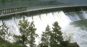
After 30 Years - Water Power LicensesAfter the 2004 Wuskwatim environmental reviews and hearings Manitoba's Clean Environment Commission (CEC) recommended that: Recommendation 7.6: The Government of Manitoba require Manitoba Hydro to resolve all outstanding issues with regard to the Churchill River Diversion, the Augmented Flow Program and Lake Winnipeg Regulation. Following resolution of these issues, Manitoba Hydro should apply for the appropriate final licences for these three operations under The Environment Act and The Water Power Act as soon as possible. Recommendation 7.7: The application for the approval of final licences for Churchill River Diversion, Augmented Flow Program and Lake Winnipeg Regulation should include a review of the terms and conditions, an operational review and any required environmental impact assessments. Clear guidelines should be developed with respect to what constitutes conformance to and/or violation of the terms under these licences. Manitoba Wildlands, the Interfaith Task Force on Hydro Development, and northern communities believe the CEC recommendations mean both environmental and water power licenses and reviews must be undertaken. The CEC panel ultimately agreed with a public participants motion filed summer 2003, supported by public participants, that the Wuskwatim generation project area was insufficient, excluded impacts that would be felt elsewhere in the hydro (CRD) system. 
During the 2007 cabinet appeal of the Wuskwatim project licences, the director of environmental approvals under Manitoba's Environment Act confirmed that "The Minister of Water Stewardship has directed that outstanding issues related to the Churchill River Diversion project be addressed in order to allow for the consideration of the issuance of the CRD final licence under the Water Power Regulation under the Water Power Act." Water Stewardship Minister Melnick has confirmed that consultations with affected Aboriginal communities will begin soon, and that a public process for public comments and a public registry will be put in place. A September 17 meeting in Thompson, Manitoba, began the process with some potentially affected Aboriginal communities. A review of documents and correspondence shows that Manitoba Hydro is requesting the current interim water power licences be combined into one permanent licence, for 50 years. Currently Manitoba Hydro maintains that the generation stations in its system do not need any environmental permits or licences. The dams also were not grandfathered during the 1980s under Manitoba's Environment Act, as many other installations and plants were. No independant cumulative assessment of the CRD system, or generation stations throughout the province has been conducted. Manitoba Wildlands continues to expect the full intent of the CEC recommendation to be acted on.
|
||||


Environmental Licensing
 Environmental licensing in Manitoba occurs through The Environment Act. The Environmental Assessment and Licensing Branch of Manitoba Conservation is responsible for all stages of environmental licensing in Manitoba. See their licence application details here. Environmental licensing in Manitoba occurs through The Environment Act. The Environmental Assessment and Licensing Branch of Manitoba Conservation is responsible for all stages of environmental licensing in Manitoba. See their licence application details here.In Manitoba, most major projects and development undertakings require an environmental license. Typically, these projects also require various other licenses or permits or authorizations under other provincial and federal legislation. The level of scrutiny for development projects that must undergo environmental assessment depends on the classification or 'class' of the development. The Classes of Development Regulation 164/88 defines various development projects as Class 1, Class 2 or Class 3 Developments and all developments described in the regulation require an environmental license. View Manitoba Environment Act Class 1, 2 & 3 Developments, Manitoba Wildlands CEAA 101: A Workshop on Environmental Assessment Download February 2009, CEAA 101: A Workshop for Citizens on Environmental Assessment (PDF) Download February 2009, CEAA 101: A Workshop for Citizens on Environmental Assessment (PDF)Canada - Manitoba Agreement On Environmental
|
National Energy Board
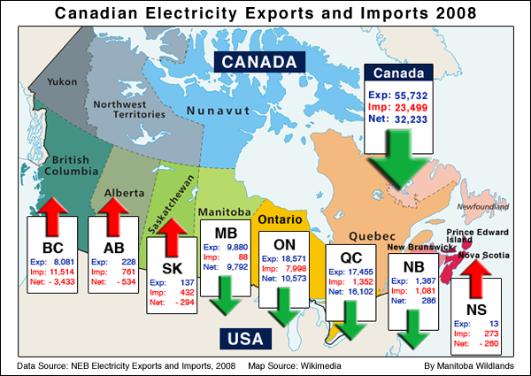
The NEB's corporate purpose is to "promote safety, environmental protection and economic efficiency in the Canadian public interest within the mandate set by Parliament." It operates under the National Energy Board Act, with responsibilities under other sets of legislation as well. Visit the National Energy Board website View the National Energy Board responsibilities Manitoba Hydro has a series of NEB licenses that permit the company to sell electricity into the United States. (No NEB licenses are required for sale into Canadian provinces.) Manitoba Hydro also operates four transmission lines that connect with American markets. These also fall under the purview of the NEB. Export of energy to the United States is central to the operations of Manitoba Hydro. Between 1999 and 2004 Manitoba Hydro sold 30.5% of the energy it generated into American markets (measured by revenue rather than kilowatt hours). Between 2004 and 2008, that number slightly increased to 33%. Manitoba Hydro exports energy to dozens of American companies including Minneapolis-based Xcel Energy. Sources: National Energy Board and Manitoba Hydro Annual Reports |
Energy Development
Manitoba Forest Companies & Tenure
Mining
 Manitoba's mineral industry is dominated by nickel, gold, and copper mines with specialty minerals like cesium being mined more recently. The peat, sand and gravel, and stone industries are also active in the province. Exploration for diamond have occurred in the last 10 years.
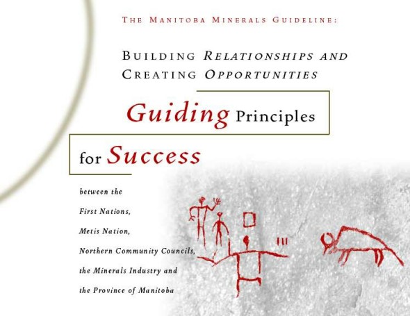
In 1999, Manitoba's Minerals Guideline: Guiding Principles for Success was confirmed. Access the Guideline at ITM - Manitoba Minerals Guideline. Mining in Manitoba is governed by the Mines and Minerals Act - a relatively new piece of legislation. It was initially developed and enacted in 1991-92 and has been amended since then. The Act reflects some progressive environmental and social concepts such as sustainable development and acknowledges the rights of those who occupy lands (prior to any activity to secure mining tenure), and the public's right to access information. The Mines and Minerals Act includes a section that gives the Minister discretionary power to withdraw open Crown mineral land from exploration, staking and lease (Mines and Minerals Act, Section 14(1)). This is important because it gives the Minister considerable power to close areas of the province to mining (by issuing an order that results in a regulation). In most other jurisdictions, all lands are open to mining activity unless closed through other legislation (for instance legislation that prohibits mining activity in parks and/or protected areas). Through this Manitoba legislation, (Section 52(1)) Cabinet has the power to make regulations that designate areas for which mineral exploration licenses may not be given. 
The discretionary power for the Minister and Cabinet to say 'no' to mining activity is in keeping with the commitment to sustainable development principles that is clearly voiced in the Act, The object and purpose of this Act is to provide for, encourage, promote and facilitate exploration, development and production of minerals and mineral product in Manitoba, consistent with the principles of sustainable development.
Mines and Minerals Act, Section 2(1)
Some Crown land areas of the province are not open to (prospecting) license holders for mineral exploration and staking of claims (Mines and Minerals Act, Section 61(1), Section 160). These areas include:
1 "mineral disposition" means a claim, an exploration permit, a special exploration
permit or a quarry permit (Mines and Minerals Act) Peat Mining in ManitobaPresentation to Mines Ministers The National Mines Ministers Conference (MMC) was held in Winnipeg September 17, 18 2002. Each year all governments in Canada, represented by ministers responsible for mining, meet to discuss common challenges and policy initiatives. The theme conference was, "The Top Three Priorities: Sustainable Development of Mining in Canada". The National Mines Ministers Conference (MMC) was held in Winnipeg September 17, 18 2002. Each year all governments in Canada, represented by ministers responsible for mining, meet to discuss common challenges and policy initiatives. The theme conference was, "The Top Three Priorities: Sustainable Development of Mining in Canada".Gaile Whelan Enns, Manitoba Director, Wildlands Campaign, Canadian Nature Federation made a presentation entitled, "Manitoba's Protected Areas Commitments, The Mining Sector Consultation - Working Toward Sustainability" . Her presentation provides background about the Manitoba Mining Sector Protected Areas Consultation. It provides a history of the consultation and describes the technical basis used, partners involved, and mechanism to rank areas for protection. View Presentation to Mines Ministers Conference (without maps) Download DOCDownload PDF Maps (4.6MB)View Canadian Mines Ministers Conference - Open Session Transcript (CNF presentation highlighted in red) Download DOC
Award for Protected Areas Consultation During the September 2002 National Mines Ministers' conference in Winnipeg, the Prospectors and Developers Association of Canada (PDAC) presented Manitoba Minister Mihychuk its annual 'claim stakers' award. This award acknowledges Manitoba's multi year mining sector consultation for the establishment of protected areas. It also acknowledges the government of Manitoba for its participation in the mining sector's protected areas consultation. Each year the PDAC 'claim stakers' awards acknowledge government actions and public policy initiatives for the mining sector.
Visit the PDAC website The Manitoba Geological Survey web site contains information about all current dispositions and properties in Manitoba. Their Map Gallerycan be accessed at ITM - Geological Survey - GIS map gallery. |
Transportation
Sustainable Development
 Manitoba's Sustainable Development Act includes a set of principles and guidelines. We are posting access to the Act, significant reports, public policies, and initiatives identified by government as being part of sustainable development for Manitoba. From 1997 to 1999 the Manitoba government undertook the Consultation on Sustainable Development Implementation (COSDI). Many of the recommendations from COSDI are the basis for current sustainable development policy and regulatory changes. It should be noted that environmental organizations did not sign off on COSDI. Also the intended public consultation regarding COSDI recommendations has not occurred. Please see our Links and Governments pages. Manitoba's Sustainable Development Act includes a set of principles and guidelines. We are posting access to the Act, significant reports, public policies, and initiatives identified by government as being part of sustainable development for Manitoba. From 1997 to 1999 the Manitoba government undertook the Consultation on Sustainable Development Implementation (COSDI). Many of the recommendations from COSDI are the basis for current sustainable development policy and regulatory changes. It should be noted that environmental organizations did not sign off on COSDI. Also the intended public consultation regarding COSDI recommendations has not occurred. Please see our Links and Governments pages. View the Sustainable Development Act View the Sustainable Development Principles and Guidelines View the Consultation On Sustainable Development Implementation (COSDI) Report Download Provincial Sustainable Development Code of Practice (DOC)Download Sustainable Development Financial Management Guidelines (DOC)View 1993 NRTEE report, Building Consensus for a Sustainable Future: Guiding Principles Sustainable Development Links, |
||||
 2002-2014