
Manitoba Land Use Planning
Currently, single development/environment licensing and regulatory processes provide the only forum for significant large-scale land use decisions, such as forestry, hydro generation stations, new mines or mills, highway or transmission systems. Community involvement, transparent access to information in advance of decisions, independent cumulative environmental assessment, are not adequately addressed prior to land use decisions. Protected areas establishment, while public policy for all natural regions in Manitoba, is often ignored or given a token place in environmental impact statements prior to licensing processes.
 Manitoba's current (and past) land use decisions have been made without coordinated large area land use plans. Many development decisions in southern Manitoba have been made without planning bylaws or plans in place.
The need for coordinated and integrated large area land use planning in Manitoba has been recognized and debated for over twenty years. In fact, a mechanism for land use planning already exists in certain modern treaties between affected First Nations, Manitoba, Manitoba Hydro and Canada. However, only a few First Nations in Manitoba have the resources to undertake traditional land use studies. Such studies are needed before land use planning can take place, and well before any significant development decisions are made. The main finding of the 1999 COSDI Report (See Sustainable Development on Economic Development Page) is that Manitoba must change from a system where 'development drives planning' to land use decisions based on planning that takes into account: community equity on an intergenerational basis; affected community rights and expectations; the current and future economy; and the ecological sustainability of our ecosystems. Societal values must be part of the basis for land use plans. Public policy commitments for protected areas, species protection, water quality, carbon sinks, among others, must be fulfilled before developments further impact our natural regions. The Manitoba government initiated a large area land use planning process for the east side of Lake Winnipeg in 2001, called the East Side Planning Initiative. For details about Phase One and Phase Two go here. |
Large Area Land Use Planning by Ajit K. Krishnaswamy
Ph.D. (April 2000 for Whelan Enns Associates) defines land use planning as having the following characteristics
(adapted from Brown, 1996);
|
Lands and Waters Brief ReportsSierra Club Report - Manitoba Case StudyCriteria based on Canada's National Forest Strategy commitment to undertake land use planning as part of an ecosystem-based approach to forest management were used. Manitoba's East Side Planning Initiative (ESPI) is one of the case studies and one of Manitoba Wildlands was involved in finalizing the case study. The Sierra Club of Canada report contains several recommendations for Phase III of Manitoba's ESPI. View the Sierra Club of Canada release View the Sierra Club of Canada report  Download Manitoba case study (PDF)Download Executive Summary (PDF) Download Manitoba case study (PDF)Download Executive Summary (PDF)View the Manitoba Wildlands' July 29, 2004 news item  Boreal Planning WorkshopMore than eighty people from seventeen First Nations and nine conservation groups gathered in Thunder Bay, Ontario in January 2004, to discuss how they could work together to care for the intact boreal region of Ontario and Manitoba. Manitoba Wildlands, along with the Wildlands League (Ontario) and Pikangikum First Nation hosted the workshop. At the workshop, Shared Values in the Heart of the Boreal, key Aboriginal speakers and experts from across Canada with leadership in land use planning presented their experiences and lessons learned from their respective regions. Elders played an important role in sharing their knowledge and guiding the direction of the bilingual workshop (carried out in both Ojibway and English). Through an open and respectful dialogue participants acknowledged challenges in the past but also the urgency and opportunity for future collaboration between First Nations and conservation groups.Download January 2004 workshop proceedings, Shared Values in the Heart of the Boreal (PDF)
 |
East Side of Lake Winnipeg
| On August 9, 2000, the Government of Manitoba announced that they would initiate broad area planning on the east side of Lake Winnipeg as a pilot for broad area planning across the province. The government's decision to begin comprehensive, coordinated large area land use planning in Manitoba was in direct response to a number of recommendations of the 1999 COSDI report (See Sustainable Development on Economic Development Page). COSDI concluded that Manitoba must change from a system where 'development drives planning' to a system where large area land use planning, based on sound social, environmental and economic principles, drives development decisions. |
Canadian Parks and Wilderness Society Election Survey, Sept. 28, 1999 Question:Would you require comprehensive land
use planning on the East Side of Lake Winnipeg before
the building of an all–weather road or the granting of
expanded logging rights to Pine Falls Paper Company or
others?
Response:An NDP government would require comprehensive
land use planning on the East Side Road issue. We would
follow the recommendations of the COSDI Report. The NDP
is also committed to ensuring open dialogue with the First
Nations on environment and development issues. In general,
the NDP is committed to implementing meaningful land and
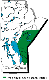
water use strategies. 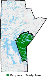 East Side Planning Area as of September 2002 Manitoba Election Survey 2003 by Manitoba Wildlands Natural Regions of Manitoba 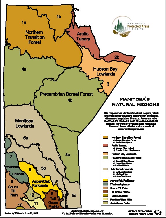 Larger Image Download PDF of Natural regions map |
|||
| These regions of Manitoba, with 25 million hectares of boreal forest lands and waters, remains mostly in its natural state with the forest ecosystem intact. Most of these natural regions (5c, 4c, 4b, 3 – see Natural Regions of Manitoba map below) do not have permanent highways or transmission corridors, hydro dams, forestry operations, or other mills or plants. "We are committed to comprehensive land and water use planning throughout Manitoba"
– Sept. 13, 1999 Election Promise – New Democratic Party View 1999 Election Promises View 2003 Election Promises View 2007 Election Promises |
||||
The traditional lands of sixteen First Nations in three tribal councils cover the region. First Nations affected include:
|
||||
| Existing and Proposed Roads - East Side Manitoba Map |
||||
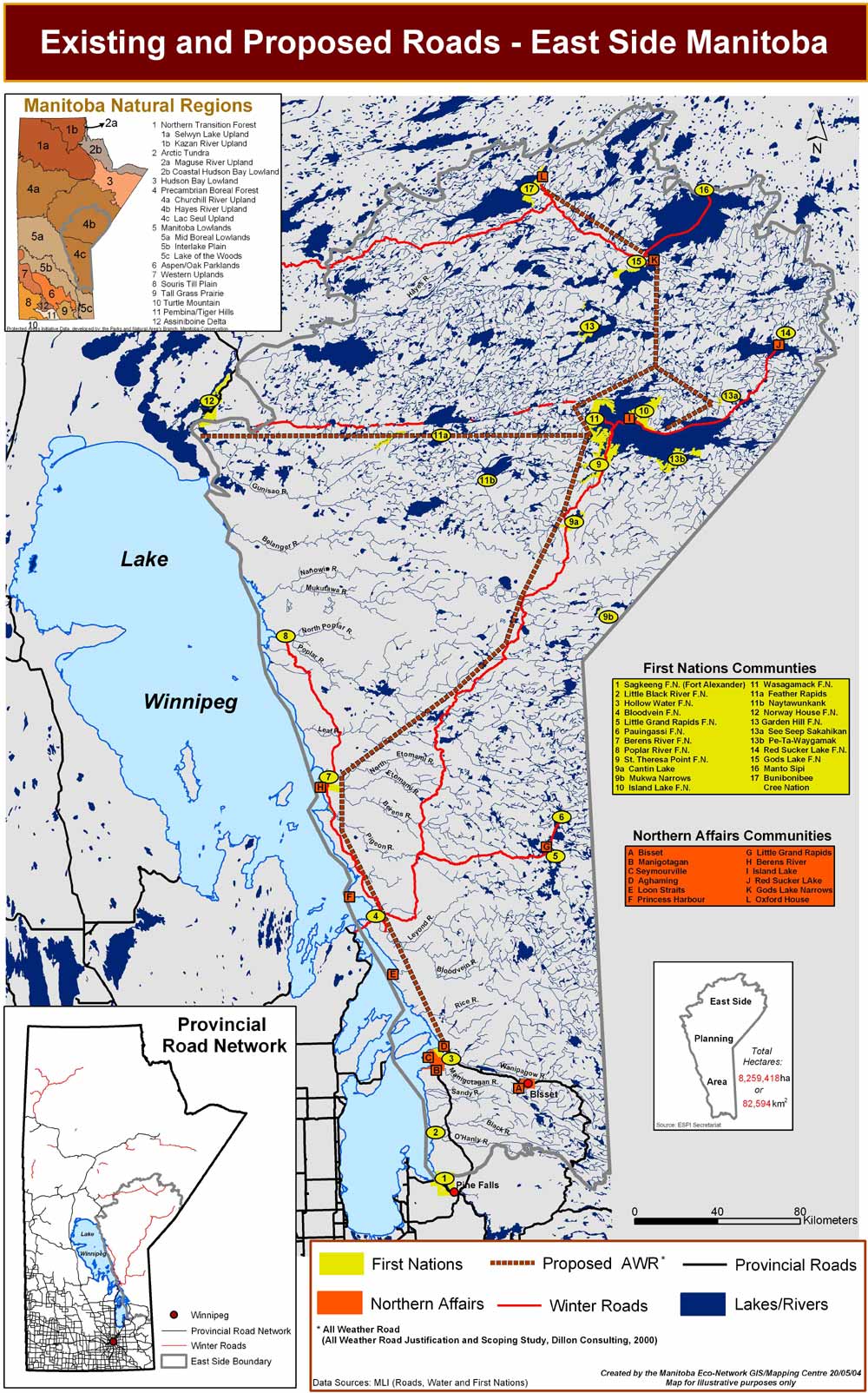 Larger Image |
Posted here is a June 2004 Manitoba Eco-Network map of the East Side Manitoba showing: winter (ice) roads, proposed all weather roads, and the current road system. Community access, especially in the face of climate change, is a challenge for many East Side communities. | |||
East Side Protected Areas
| East Side of Lake Winnipeg Manitoba Land Use Planning Area 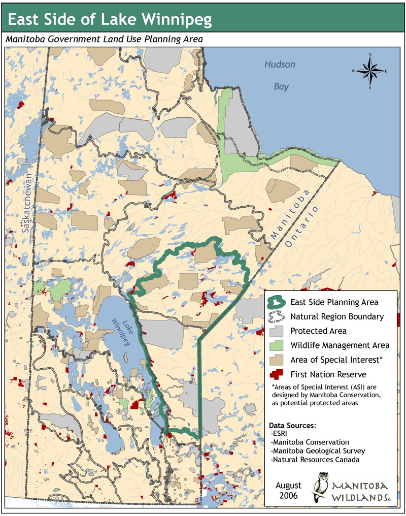 Larger Version |
There were no protected areas in natural regions northeast of Lake Winnipeg (Natural Regions 3 & 4b), until you reach Wapusk National Park bordering the western shore of Hudson Bay in Natural Region 2b. East of Lake Winnipeg, one wilderness park fully protected from development, one traditional territory fully protected from development and two natural parks with zones protected from development plus zones that allow resource extraction occupy 1.5 million ha. |
||||||
| Manigotagan River Park, an area of area of about 7,000 hectares, designated and announced December 2004. It protects a 750 metre buffer on either side of the Manigotagan River, near Nopiming Provincial Park. View a map of the Manigotagan River Park Recently designated protected areas on the east side include: Kaskatamagan Sipi Wildlife Management Area (133,820 ha), Kaskatamagan Wildlife Management Area (259,530 ha) protected under the Wildlife Act in 2009. Observation Point Wildlife Management Area (6010 ha), Pinawa Dam Provincial Park (112.5 ha) and Whitemouth Bog Wildlife Management Area (3010 ha) were protected under the Wildlife Act and Parks Act in 2008 and 2009. Potential development intentions for the region include: hydro generation stations at the top of the East Side; highway and community access road construction projects; main stem electrical transmission corridors from the north to the bottom of the East Side; expansion of forestry operations, including additional mills and substantial increase in both logging roads, and fiber allocation. Public policy commitments for completion of protected areas networks; species protection - especially woodland caribou; water source and quality protection; and to maintain carbon sequestration, must be fulfilled before developments further impacts these natural regions. There are several significant areas of special interest under review for protected status in the regions north east of Lake Winnipeg. First Nation communities also have the option to nominate lands for protection from industrial development. For more information regarding protected areas in Manitoba go here. For information regarding the World Heritage Site nomination for the east side go here. Download Areas of Special Interest Map (PDF)
| |||||||

World Heritage Site
East Side Planning Initiative
Land Use Planning/Traditional Use Studies Links,
 2002-2014